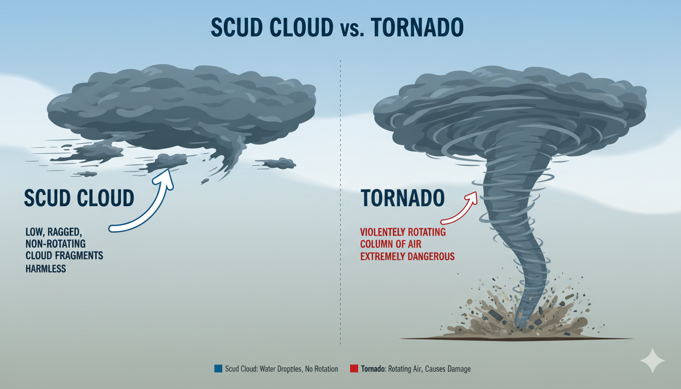
Have you ever looked up at the sky during a bad storm and felt a sudden chill? The sky turns dark, and you see eerie, ragged pieces of cloud low to the ground. They seem to be moving fast and twisting. Instantly, you think a tornado is forming right above your house. You feel your heart race as you watch the dark shapes shift in the wind.
But wait, don’t panic just yet! There is a very good chance you are looking at a scud cloud. These strange formations fool thousands of people every single year. They look incredibly scary and dangerous, but they are actually harmless on their own. In this complete guide, we will break down exactly whats a scud cloud, why it forms, and how you can tell it apart from a real, dangerous tornado. Let’s dive in and learn how to read the sky like a pro meteorologist!
What is a Scud Cloud and How Does It Form?
To understand a scud cloud, we need to look at how a thunderstorm breathes. When a storm pours down rain, it creates a lot of cold air that rushes down to the ground. This is called an outflow. At the same time, the warm air near the ground gets sucked up into the storm. When that warm, moist air meets the cold rain air, it cools down very quickly.
This rapid cooling causes water vapor to turn into visible cloud bits right below the main storm. Because these bits form in a very messy, windy area, they look ragged and torn apart. Scientists officially call them pannus clouds, but most people just call them scud. They are basically just low-lying scraps of condensation catching the wind. They do not have a solid connection to the main storm structure above them, which is a major hint about their true nature.
Understanding the True Scud Cloud Meaning
If we look at the official scud cloud meaning, it comes from an old aviation and weather term. “Scud” originally meant wind-driven rain or mist moving rapidly. In modern weather terms, it means scattered, low fragments of clouds that are totally detached from the upper cloud base. They are the drifters of the sky, blowing around aimlessly in the storm’s chaotic winds.
When meteorologists see a scud cloud, they do not see an immediate threat. Instead, they see a sign that the atmosphere is full of moisture and active wind currents. It tells them that the storm is inhaling warm air and exhaling cold air quite rapidly. Understanding this meaning helps storm spotters stay calm. It allows them to focus their attention on searching for actual severe weather features instead of getting distracted by these harmless imposters.
What Does a Scud Cloud Look Like to an Observer?
If you are standing outside, what does a scud cloud look like to the naked eye? Imagine taking a regular, fluffy white cloud and tearing it into messy, ragged shreds. Now, color those shreds a dark gray or charcoal color and hang them very low to the ground. They often look like wisps of smoke rising from a fire or tattered rags floating in the breeze.
A scud cloud will usually move much faster than the larger storm clouds above it. You might see it rising rapidly or scurrying sideways across the horizon. Because they are so low, they can block your view of the hills or tall buildings. They look spooky because they have no smooth edges. They look completely wild, chaotic, and disorganized, which is why they scare so many people who are watching the weather.
The Fear of the Intimidating Black Scud Cloud
During a severe summer afternoon thunderstorm, you might look out your window and spot a giant, black scud cloud. When these cloud fragments are positioned between you and the sun, or when they are dense with moisture, they cast deep shadows. This makes them look incredibly dark, almost like charcoal or thick black smoke rolling across the neighborhood.
Seeing a black scud cloud can be terrifying because black is a color we naturally associate with severe weather damage. However, the dark color just means the cloud is thick enough to block out the sunlight. It does not mean the cloud contains a hidden vortex or a dangerous funnel. It is simply a very wet, very low piece of vapor moving quickly through the storm’s damp underbelly.
Scud Cloud vs Funnel Cloud: Spotting the Key Differences
Learning the difference in a scud cloud vs funnel cloud matchup can save you from a lot of unnecessary worry. A funnel cloud is a rotating column of air that is actively extending down from the base of a wall cloud. It has a very smooth, cone-like, or needle-like shape. Most importantly, it is spinning rapidly around a central point, like a top.
On the other hand, a scud cloud is completely ragged and has no defined shape. While it might rise or move sideways quickly, it does not spin like a top. If you look closely at the top of a scud piece, you will see it is not firmly attached to a rotating cloud base. It is just floating underneath it. Funnel clouds are smooth and spinning; scud clouds are ragged and tumbling.
Scud Cloud vs Tornado: How to Know the Truth
When it comes to a scud cloud vs tornado, the stakes are much higher. A tornado is a violent, rotating column of air that touches the ground and is attached to a thunderstorm. Tornadoes cause massive destruction, rip up trees, and carry heavy debris into the air. They are a major emergency that requires you to seek shelter immediately in a basement or interior room.
A scud cloud cannot hurt you. It does not have strong, destructive winds inside itself, and it does not touch the ground as a unified spinning column. Sometimes, a scud piece might look like it touches the ground because it is floating so incredibly low. However, if you look for flying debris or a spinning motion, you won’t find it. Scud just drifts and tumbles without causing any damage to homes.
Can a Scud Cloud Turn into a Tornado?
One of the most common questions people ask weather experts is: can a scud cloud turn into a tornado? The short and direct answer is no, a scud cloud cannot directly transform into a tornado. Because scud lacks a rotating updraft, it does not have the physical ingredients required to create a dangerous, spinning vortex on its own.
However, there is a small catch that you should know. A scud cloud often forms in the exact same environment where tornadoes are possible. Sometimes, a real rotating wall cloud will suck up nearby scud pieces into its vortex. When this happens, the scud is just feeding into an existing threat, not creating a new one. So, while the scud itself won’t turn into a monster, it proves the storm has plenty of moisture to make nasty weather.
Why Do People Frequently Misidentify These Clouds?
It is incredibly easy to make a mistake when looking at a fast-moving scud cloud. When we are stressed about severe weather, our brains naturally look for danger. If we see a dark, pointy cloud moving fast near the ground, our mind instantly jumps to the worst-case scenario. This is a normal human survival instinct, but it causes many false tornado alarms.
Optical illusions also play a massive role in these mix-ups. From a distance, a long, pointy scud cloud hanging low over a line of trees can look exactly like a wedge tornado. If the wind is pushing the cloud upward, it can mimic the rising motion of a real funnel. Without binoculars or training, even experienced people can get tricked for a few minutes until they notice the lack of rotation.
How to Safely Watch and Analyze Storm Clouds
If you enjoy watching storms, you can learn to analyze a scud cloud safely from your porch or window. The number one rule of storm spotting is to look for organized rotation. Take a deep breath, calm your mind, and stare at the cloud for a full 30 to 60 seconds. Do you see the cloud spinning like a merry-go-round, or is it just lifting and shredding apart?
If the scud cloud is just tumbling like a piece of paper in the wind, you are perfectly safe. You can enjoy the dramatic view of nature without fear. However, you must always keep an eye on the sky and listen to your local weather radio. If the storm as a whole is severe, you should stay indoors and away from windows, even if the specific cloud you see is harmless scud.
Conclusion
Understanding what a scud cloud is can change how you feel during a scary summer storm. These ragged, dark, and fast-moving clouds look like they belong in a disaster movie. Yet, they are just harmless patches of condensed water vapor created by the storm’s cold and warm winds mixing together. They are the ultimate optical illusion of the sky.
Next time you see a spooky, low-hanging scud cloud, you don’t have to panic or run for the basement in fear. Look for rotation, check if it has smooth edges, and see if it is truly spinning. By staying informed and learning these simple weather facts, you can appreciate the power of nature while staying perfectly safe and calm.
(FAQs)
What causes a scud cloud to form?
A scud cloud forms when warm, moist air near the ground is rapidly cooled by the chilly outflow of air and rain from a nearby thunderstorm. This quick cooling causes the moisture in the air to condense into low, ragged cloud pieces that get blown around by the storm’s chaotic winds.
Is a scud cloud dangerous to people on the ground?
No, a scud cloud is completely harmless. It does not contain violent winds, it does not rotate, and it cannot damage houses or trees. It only looks scary because it hangs low to the ground and moves quickly, but it is just harmless water vapor drifting in the wind.
How can I tell a scud cloud apart from a real tornado?
The easiest way to tell them apart is by looking for rotation. A tornado rotates very fast around a central point and has a smooth, organized shape. A scud cloud looks like a torn rag, has rough edges, and tumbles or rises without any organized spinning motion.
Why do scud clouds look so dark and black sometimes?
A black scud cloud looks dark because it is very low to the ground and dense with water. When it blocks the sunlight from passing through, it casts a heavy shadow. The dark color is just an optical effect and does not mean the cloud is dangerous or angry.
Do scud clouds mean a tornado is coming soon?
Not necessarily. While a scud cloud shows that a thunderstorm has a lot of moisture and strong winds, it does not mean a tornado is about to form. Many ordinary, non-severe thunderstorms produce scud clouds without ever creating a tornado or causing any damage.
What should I do if I see a scary cloud that looks like scud?
If you see a suspicious cloud, watch it closely for a minute. If it is not rotating, it is likely just a scud cloud. However, if you are under a severe thunderstorm warning, you should always stay indoors, check your local radar, and listen to weather updates to stay safe.